VR Resources Confirms Mafic-Ultramafic Intrusion with Magmatic Sulfide in First Two Drillholes at Empire Project, Ontario
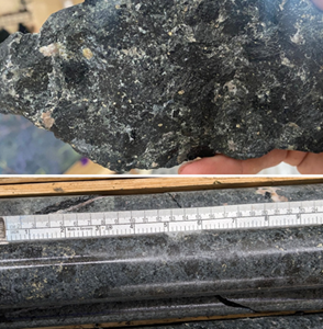
/EIN News/ -- VANCOUVER, British Columbia, Dec. 10, 2024 (GLOBE NEWSWIRE) -- VR Resources Ltd. (TSX.V: VRR, FSE: 5VR; OTCBB: VRRCF), the "Company", or “VR”, is pleased to announce it has completed the first two holes of the maiden drill program at its Empire Project in Northwestern Ontario. Drilling now confirms the Westwood magnetic target is a large mafic-ultramafic complex, showing magmatic sulfide segregations consistent with the showing over 600m to the west on the Trans Canada Highway, and shown in Photo 1. At least one more drill hole is planned at Empire before the holiday break, approximately 700 m to the north of Holes 1 and 2 to test the opposing margin of the intrusive complex.
IP Drill Targeting
Drilling to date on the Westwood target has focused on testing integrated features from the three independent surveys over the target shown in Figure 1, namely strong IP chargeability on Lines 1 and 3 correlating with the 2km long magnetic anomaly with coincident DIGEM conductivity.
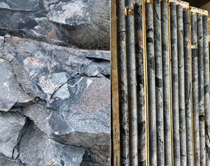
Drill hole 1, WW24-001, 249 metres, focused on the strongest chargeability response of 18mV/V on Line 3, coinciding with strong vertical gradients on the eastern margin of the 2km long, NE-striking Westwood magnetic anomaly. Drilling intersected 240m of leucocratic gabbro and 1-2% pyrite-pyrrhotite with strong evidence of mafic-ultramafic magma mixing and brecciation throughout the hole (Photo 2).
Drill hole 2, WW24-002, 495 metres, was drilled from the same pad as Hole 1 but directed to the southwest into the coincident magnetic high and airborne DIGEM conductivity anomaly with a 10-15 mV/V chargeability anomaly. The hole began in the same leucocratic gabbro before transitioning at 45m into a gradually coarsening mafic-ultramafic intrusive with magmatic sulfide through to the end of the hole. 4 rush samples of the strongest sulfide are now at the lab in Thunder Bay for gold, copper, PGE and trace element analysis.
From VR's CEO Justin Daley: “The first two holes ever drilled at the Empire project have now given us a proof of concept for the large mafic-ultramafic intrusions inferred from the magnetic survey flown last winter. The goal for this drill program was simple: to test our integrated geophysical targets for a larger interval of the mafic rock with sulfides observed along the Trans Canada exposure, and Holes 1 and 2 have shown us just that. We look forward to providing further updates as we complete remaining holes planned on the other side of the complex, and as we receive assay results on this first batch of samples of sulfide in the first two holes.”
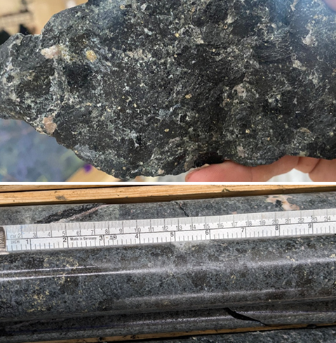
Photo 1. Trans Canada highway exposure sample in upper photo, from the southwestern end of the 2km long magnetic anomaly shown in Figure 1, alongside similar mafic-ultramafic intrusive rock from 318m depth in Hole 2 shown in the lower photo. In both photos, the coarse-grained texture contains disseminated or interstitial sulfides. Continuous sampling is underway through the mafic intrusion with sulfide, with rush samples sent on a 4 select samples.
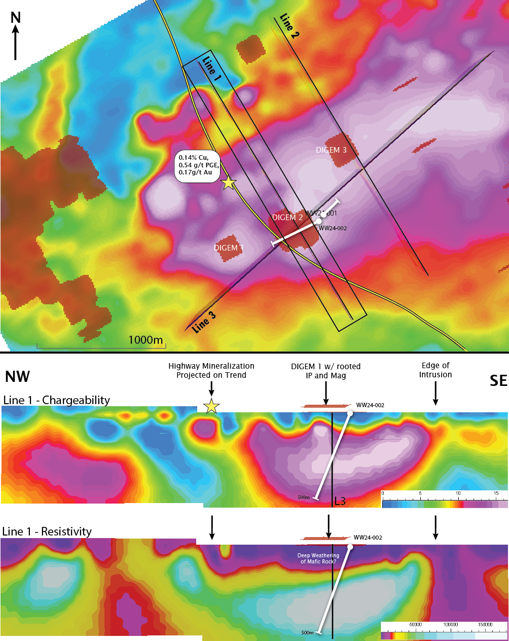
Figure 1. Drill hole locations shown on a total magnetic intensity map for the Westwood target at the Empire Project, with Photo 1 sample location, overlain 900Hz DIGEM anomalies, and completed IP section lines. The surface showing near the highway of copper-gold mineralization is on the western edge of a large, magnetic anomaly over 2km in length. The lower panels highlight the direct correlation of chargeability and resistivity in the new DCIP survey.
About the Empire Project
The Empire project consists of 313 mineral claims in 1 contiguous block covering 10,254 hectares. The project is located on Federal crown land, with mineral rights administered by the Ontario Ministry of Mines. There is a 2% net smelter royalty on the claims. There are no annual payments, but the Ministry requires certain annual exploration expenditures and reporting (ie. mineral assessment reports) in order to maintain a mineral claim in good standing. The project falls within the Lac de Mille Lacs First Nation traditional territories.
Technical Information
Surface grab samples and drill core samples were submitted for geochemical analysis to the AGAT laboratory in Thunder Bay, Ontario. Drill core was logged, cut and sampled at the Holbik Exploration warehouse in Upsala, Ontario, with sample preparation completed by AGAT in Thunder Bay alongside gold and PGE determination by atomic absorption assay. ICP-MS analyses for base metals, whole rock, and trace elements is performed at AGAT’s laboratory in Calgary, AB. Analytical results are subject to industry-standard and NI 43-101 compliant QAQC sample procedures, including the systematic insertion of sample duplicates, blanks and certified reference material (CRM) done both externally and internally at the laboratory by AGAT, as described by AGAT.
Technical information for this news release has been prepared in accordance with the Canadian regulatory requirements set out in National Instrument 43-101. Justin Daley, P.Geo., President & CEO at VR and a non-independent Qualified Person oversees and/or participates in all aspects of the Company’s mineral exploration projects, and the content of this news release has been reviewed on behalf of the Company by the Executive Chairman, Dr. Michael Gunning, P.Geo., a non-independent Qualified Person.
About VR Resources Ltd.
VR is an established junior exploration company based in Vancouver (TSX.V: VRR; Frankfurt: 5VR; OTCQB: VRRCF). VR evaluates, explores and advances opportunities in copper, gold and critical metals in Nevada, USA, and Ontario, Canada. VR applies modern exploration technologies, in-house experience, and expertise in greenfields exploration to large-footprint systems in underexplored areas/districts. The foundation of VR is the proven track record of its Board in early-stage exploration, discovery and M&A. The Company is financed for its mineral exploration and corporate obligations. VR owns its projects outright and evaluates new opportunities on an ongoing basis, whether by staking or acquisition.
ON BEHALF OF THE BOARD OF DIRECTORS:
“Justin Daley”
Justin Daley, MSc, P.Geo
President & CEO
For general information please use the following:
Website: www.vrr.ca
Email: info@vrr.ca
Phone: 778-731-9292
Forward Looking Statements
This news release contains statements that constitute "forward-looking statements". Such forward looking statements involve known and unknown risks, uncertainties and other factors that may cause the Company’s actual results, performance or achievements, or developments in the industry to differ materially from the anticipated results, performance or achievements expressed or implied by such forward-looking statements. Forward-looking statements are statements that are not historical facts and are generally, but not always, identified by the words "expects," "plans," "anticipates," "believes," "intends," "estimates," "projects," "potential" and similar expressions, or that events or conditions "will," "would," "may," "could" or "should" occur. Forward-looking statements in this document include statements concerning VR’s plans for near-term drilling on the properties this fall, and all other statements that are not statements of historical fact.
Although the Company believes the forward-looking information contained in this news release is reasonable based on information available on the date hereof, by their nature forward-looking statements involve assumptions, known and unknown risks, uncertainties and other factors which may cause our actual results, performance or achievements, or other future events, to be materially different from any future results, performance or achievements expressed or implied by such forward-looking statements.
Examples of such assumptions, risks and uncertainties include, without limitation, assumptions, risks and uncertainties associated with general economic conditions; adverse industry events; future legislative and regulatory developments in the mining sector; the Company’s ability to access sufficient capital from internal and external sources, and/or inability to access sufficient capital on favorable terms; mining industry and markets in Canada and generally; the ability of the Company to implement its business strategies; competition; and other assumptions, risks and uncertainties.
The forward-looking information contained in this news release represents the expectations of the Company as of the date of this news release and, accordingly, is subject to change after such date. Readers should not place undue importance on forward-looking information and should not rely upon this information as of any other date. While the company may elect to, it does not undertake to update this information at any particular time except as required in accordance with applicable laws.
This news release may also contain statements and/or information with respect to mineral properties and/or deposits which are adjacent to and/or potentially similar to the Company’s mineral properties, but which the Company has no interest in nor rights to explore. Readers are cautioned that mineral deposits on similar properties are not necessarily indicative of mineral deposits on the Company’s properties.
Trading in the securities of the Company should be considered highly speculative. All of the Company’s public disclosure filings may be accessed via www.sedarplus.ca and readers are urged to review them.
Neither the TSX Venture Exchange nor its Regulation Services Provider (as that term is defined in Policies of the TSX Venture Exchange) accepts responsibility for the adequacy or accuracy of this release
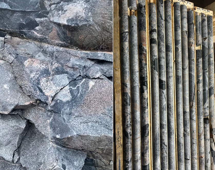
Photo 2. (left) Evidence for magma mixing just east of the mineralized mafic-ultramafic rock shown in Photo 1 from the Trans Canada Highway exposure, as part of a gradational change from leucocratic gabbro with fine-grain mafic enclaves to medium-grain mafic intrusion to coarse, sulfide-rich mafic-ultramafic rock. (Right) Interval from 130-150m in Hole 1 showing the same dynamic magma mixing textures and mafic enclaves, roughly 750m to the east of photo at left, on the outer margin of the magnetic mafic intrusion intersected in Hole 2.
Photo accompanying this announcement are available at
https://www.globenewswire.com/NewsRoom/AttachmentNg/98effb96-15fe-4d3b-bf98-aabbe672f58b
https://www.globenewswire.com/NewsRoom/AttachmentNg/10d52bd4-b76d-4bc7-a08f-a65dc6575c67
https://www.globenewswire.com/NewsRoom/AttachmentNg/3508185e-555b-4c7b-ba5f-f1fea7a546b7

Figure 1
Drill hole locations shown on a total magnetic intensity map for the Westwood target at the Empire Project, with Photo 1 sample location, overlain 900Hz DIGEM anomalies, and completed IP section lines. The surface showing near the highway of copper-gold mineralization is on the western edge of a large, magnetic anomaly over 2km in length. The lower panels highlight the direct correlation of chargeability and resistivity in the new DCIP survey.
Photo 1
Trans Canada highway exposure sample in upper photo, from the southwestern end of the 2km long magnetic anomaly shown in Figure 1, alongside similar mafic-ultramafic intrusive rock from 318m depth in Hole 2 shown in the lower photo. In both photos, the coarse-grained texture contains disseminated or interstitial sulfides. Continuous sampling is underway through this mineralization in drill core, with rush samples sent on a 4 select samples.
Photo 2
(left) Evidence for magma mixing just east of the mineralized mafic-ultramafic rock shown in Photo 1 from the Trans Canada Highway exposure, as part of a gradational change from leucocratic gabbro with fine-grain mafic enclaves to medium-grain mafic intrusion to coarse, mineralized mafic-ultramafic rock. (Right) Interval from 130-150m in Hole 1 showing the same dynamic magma mixing textures and mafic enclaves, roughly 750m to the east of photo at left, on the outer margin of the magnetic mafic intrusion intersected in Hole 2.
Distribution channels: Mining Industry ...
Legal Disclaimer:
EIN Presswire provides this news content "as is" without warranty of any kind. We do not accept any responsibility or liability for the accuracy, content, images, videos, licenses, completeness, legality, or reliability of the information contained in this article. If you have any complaints or copyright issues related to this article, kindly contact the author above.
Submit your press release


